
Seven dispersal zones to keep communities of Sefton save over Bonfire Night period
Main article content
Seven dispersal zones will be introduced in the Sefton area today, Wednesday 5 November, to ensure our communities feel safe and prevent incidents of antisocial behaviour.
Each of the zones – in Aintree, Crosby, Hatton Hill, Maghull and Netherton – will be in place from 3pm today, Wednesday 5 November until 10pm on Thursday 6 November.
Two zones - in Southport and Formby - will be in place from 4pm today until 4pm tomorrow.
They are as follows:
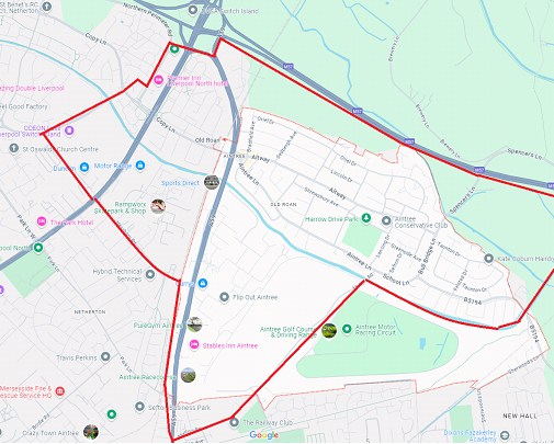
Aintree: M57, A59 Switch Island, Northern Perimeter Road, Copy Lane, Browns Lane, Edward Jenner Ave, Heysham Road, Mersey Rail Kirkby railway, Melling Road, Leeds to Liverpool Canal up to M57 including Old Roan and Aintree Railway Stations.

Crosby: Crosby Village/Alexandra Park/Coronation Park/Ramblers/Northern Club/Moorside Park area as shown on the map. The zone will cover the area bounded by Moor Lane, Forefield Lane, Moorside Park, Liverpool Road, Coronation Road.
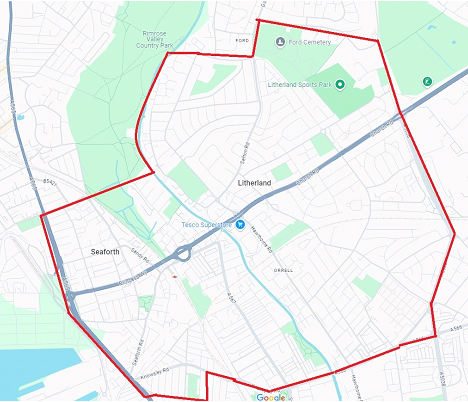
Hatton Hill: Hatton Hill Park and surrounding areas as shown on the map. The zone will cover the area bounded by Boundary Road, Sterrix Lane, Gorsey Lane, Leeds to Liverpool Canal, Rimrose Brook, Cambridge Road, A565 Crosby Rd South, Peel Rd, Norton Street, Knowsley Road, Linacre Lane, A5038 Netherton Way.
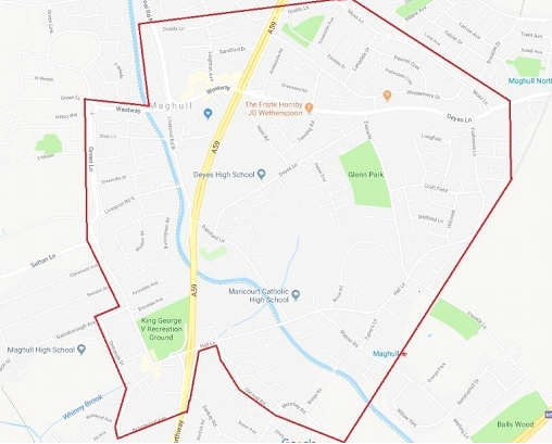
Maghull: Green Lane, Dodds Lane, Ormonde Drive, Broadwood Avenue, Hall Lane, Old Hall Road, Moss Lane.
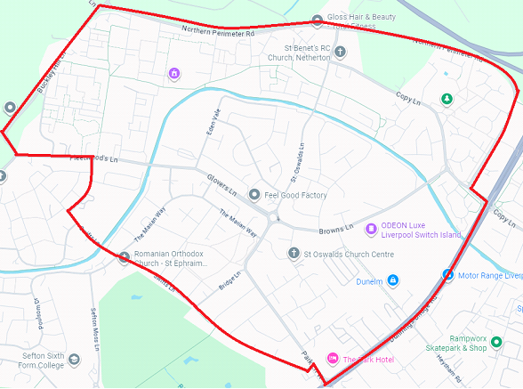
Netherton: Northern Perimeter Road, Copy Lane, Dunnings Bridge Road, Park Lane West, Barnfield Close, Swifts Lane, St Nicholas Drive, Fleetwoods Lane, Buckley Hill Lane.
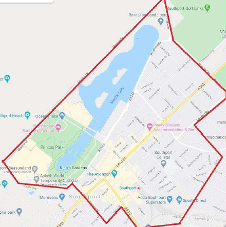
Southport: Marine Drive, Esplanade, Promenade, Coronation Walk, Portland Street, Talbot Street, Eastbank Street, Virginia Street, Southport railway station, Hall Street, Hawkshead Street, Queens Road, Park Road, Park Road West, Promenade, Fairway.
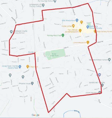
Formby: Long Lane footpath, Church Road, Liverpool Road, Altcar Lane, Hoggs Hill Lane, the railway line, Kirklake Road, Woodlands Road, Wicks Lane, Freshfield Road.
Sefton neighbourhood policing Inspector Kenneth Sumner said: “These zones are in place due to the number of calls we receive about incidents of antisocial behaviour and criminal damage over the Bonfire Night period.
“We know from past history that the dispersal zones are effective in removing groups of people gathering in certain areas and preventing incidents of ASB and we know that our communities appreciate when they see high visibility police patrols on the streets.
“As always our ask of parents and guardians is to please speak to your children teenagers and warn them against engaging in antisocial or criminal behaviour including letting off fireworks in public.”
To report anti-social behaviour or criminal behaviour can contact Merseyside Police social media desk via X @MerPolCC or on Facebook ‘Merseyside Police Contact Centre’. You can also report information via our website: https://www.merseyside.police.uk/ro/report/ocr/af/how-to-report-a-crime/ or call 101.
Operation Banger is Merseyside Police’s response to the Halloween and Bonfire Night period.
For more on the operation and Dispersal Zones, please visit: Sharp Decrease in Antisocial Behaviour in Merseyside on First Night of Operation Banger | Merseyside Police